As you may know by now, I create my own transit maps as well as write about them. But unless you’ve been following me for a while, you may not know exactly what I’ve done, and what I currently have available for purchase this holiday season. Here’s a quick rundown:
—
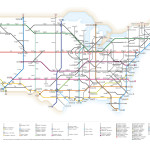
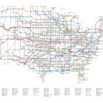
Interstates as a Subway Map and US Highways as a Subway Map
These two posters are by far my most popular items. Because I can print in bulk with my supplier, the fantastic Wallblank Printery, the price on these is excellent for the superb quality. Each 36” x 24” poster is just $39 plus $10 shipping, or you can buy a combo pack of both posters for just $68 plus shipping — a saving of $10 over buying each poster individually.
This will be the last Christmas that I offer these posters for sale, as I have plans for something bigger and better next year (which I’ve already been dropping hints about). So, if you’ve been thinking about picking one — or both — of these posters up, do it now. You won’t get another chance. Click through to the order page on my website here.
—
Not all the maps I create generate as much interest as the ones above, but I still make them available for purchase through my Society6 store. As these posters are print-on-demand, the cost per unit is a little bit higher than the ones I order in bulk through Wallblank, but these are still excellent ideas for unusual gifts for the transit geek in your life.
Note: Due to the fine type and detail in many of these maps, I really, really recommend that you purchase only the LARGE or X-LARGE print sizes that Society6 offers. You will almost certainly be disappointed (and the type will be illegible) if you go smaller than that.
—
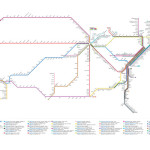
Amtrak Passenger Rail System
Fully updated for 2012, this map shows all of Amtrak’s passenger rail services — split into route lines and colour-coded in the style of a subway map. Big preview here on Flickr.
—
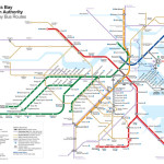
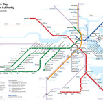
Boston Rapid Transit Map
My own original redesign of Boston’s transit map. Comes in two flavours: one with key bus routes and the other without (which I like better — the map looks so much cleaner without it).
Boston – Key Bus Routes | Boston – No Bus Routes
—
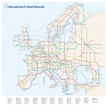
European International E-Road Network
A couple of years old now, but still one of my favourite maps. Who knew Europe had an international network of routes?
—
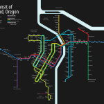
Rail Transit of Portland, Oregon
My own original version of a unified rail map of my home, Portland, Oregon. Shows MAX Light Rail and the Portland Streetcar — including the new Central Loop line on the eastside.
—
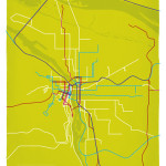
Passenger Rail of Portland, Oregon | 1912 | 1943 | 2015
Overlays passenger rail services — light rail, streetcar, interurban and intercity trains — from three different eras for a comparison of how things have changed over time.
Love this! Snackertons! You will like it too. Look at all them Nosh Blvds.